Dynamic NASA-Built Weather Sensors Enlisted to Track Tropical Cyclones
Known as COWVR and TEMPEST, the duo is demonstrating that smaller, less expensive science instruments can play an important role in weather forecasting.

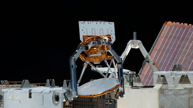
COWVR, at center, and TEMPEST, not shown, were installed aboard the International Space Station in late 2021 and since then have provided valuable weather data to forecasters tracking tropical cyclones. The two instruments are part of the U.S. Space Force STP-H8 demonstration mission. Credit: NASA
This article was discussed in our Next Byte podcast.
The full article will continue below.
NASA recently built two weather instruments to test the potential of small, low-cost sensors to do some of the work of bulkier, pricier satellites. Both instruments have exceeded expectations as trial runs, and they are already delivering useful forecast information for the most devastating of storms, tropical cyclones.
Launched in late 2021 to the International Space Station, COWVR (short for Compact Ocean Wind Vector Radiometer) measures the speed and direction of wind at the ocean surface, and TEMPEST (Temporal Experiment for Storms and Tropical Systems) provides atmospheric water vapor measurements. Both instruments are part of Space Test Program-Houston 8 (STP-H8), a three-year demonstration mission funded by the U.S. Space Force, which also funded the construction of COWVR. TEMPEST was built by NASA as a flight spare for a prior mission, and Space Force repurposed it for STP-H8.
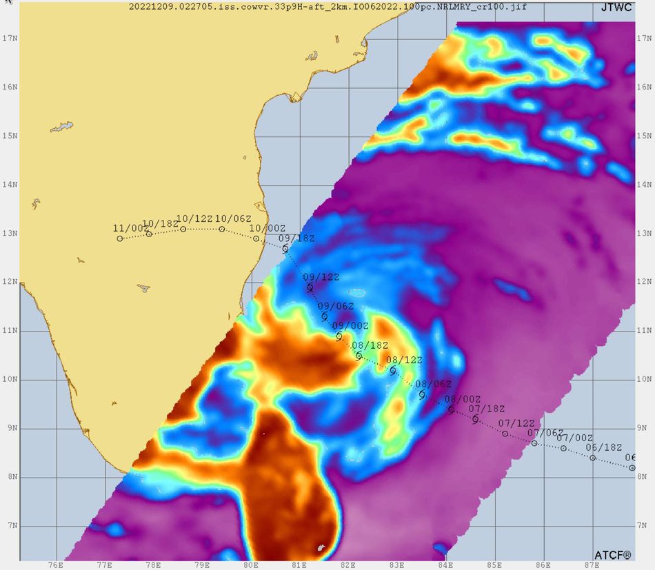
Imagery created from their data is being used by the U.S. Joint Typhoon Warning Center to track the location and intensity of tropical cyclones in the Indian and Pacific oceans. In fact, COWVR and TEMPEST images were among the sources used by a forecaster at the typhoon center in Pearl Harbor, Hawaii, to pin down the location of Tropical Cyclone Mandous, which roiled the Bay of Bengal off southern India in December 2022.
Credit: U.S. Joint Typhoon Warning Center/U.S. Naval Research Laboratory
For several months, images based on COWVR and TEMPEST data have been delivered to the center by the Monterey, California-based Naval Research Laboratory (NRL), which has been working with NASA to calibrate the instruments and validate their data. Storm forecasters have been trying out the imagery – evaluating how it affects predictions and comparing it with other data sources – said Brian Strahl, the center’s director.
Reliable, frequently updated information on storm structure and location, wind speed, and humidity is crucial to the center’s mission to track tropical cyclones between Africa’s east coast and the west coast of the Americas, an area that includes vast expanses of open ocean.
“It’s challenging outside of the continental U.S. – where you don’t have weather aircraft routinely flying – to give a really good ground-truth of where these storms are, so we’re reliant on satellites,” Strahl said. “Any new additions of good quality data, which we believe these are, can be very useful.”
Smaller, Less Costly
COWVR and TEMPEST both measure microwave emissions from Earth’s atmosphere and surface. Data from microwave readings have an advantage over those from infrared or visible light: They can give forecasters a look at the internal structure of a tropical cyclone and help them locate the eye, even if it’s obscured by clouds.
The idea for the mission emerged a decade ago as the U.S. Department of Defense (DoD) started considering the next generation of instruments that could replace sensors such as WindSat, a DoD weather radiometer that operated until 2020.
COWVR incorporates technology and designs developed at NASA’s Jet Propulsion Laboratory for the agency’s Jason series of ocean-observing satellites. With Jason, engineers had to correct for the presence of atmospheric water vapor when measuring sea surface height. With COWVR, the water vapor and how it moves are the focus.
Larger weather radiometers are often built with spinning dishes to enable broader coverage than that provided by an instrument that points straight down. COWVR also uses a rotating dish, but JPL engineers managed to simplify the instrument’s design, making it more power-efficient without compromising its capabilities.
Around the size of a minifridge, the instrument weighs about 130 pounds (60 kilograms) and requires about 47 watts to run – approximately the same power demand as an actual minifridge. WindSat, by comparison, weighed 990 pounds (450 kilograms) and used 350 watts. COWVR’s design and construction budget was $24 million, roughly one-fifth the cost of WindSat.
TEMPEST was a flight spare left over from NASA’s 2018 TEMPEST-D mission. About the size of a cereal box, it weighs roughly 8 pounds (4 kilograms), draws 6.5 watts of power, and had a budget of less than $2 million. TEMPEST-D was a CubeSat demonstration led by researchers from Colorado State University, JPL, and Blue Canyon Technologies.
“NASA developed these instruments to be compact and simple, without many moving parts, and using technology that has matured over the decades,” said Shannon Brown, principal investigator for COWVR at JPL. “We are now seeing that instruments like that can perform as well as the more expensive operational sensors.”
Separate from STP-H8, NASA also is exploring the use of data from COWVR and TEMPEST, as well as small satellites like them, for its own weather-related missions.
What’s Next
The Naval Research Laboratory has sent data from COWVR and TEMPEST to the U.S. National Hurricane Center, where forecasters have started to evaluate it. And the Joint Typhoon Warning Center intends to take a closer look at COWVR’s surface wind speed and direction data – not just the imagery – to see if it improves tropical cyclone forecasts.
The Naval Research Laboratory also continues to evaluate raw data from COWVR and TEMPEST for use in the U.S. Navy’s global numerical weather models.
“These are critical behind-the-scenes efforts that enable us to feel confident using measurements from these new instruments,” said Steve Swadley, NRL’s lead for calibration and validation of data from spaceborne microwave sensors. “So far, it looks really, really good, so that’s exciting.”
