Podcast: Eye of The Storm: NASA's New Weather & Tropical Storm Tracking Sensors
In this episode, we talk about a new satellite system from NASA that leverages technologies used in other missions to accomplish the same performance that has been delivered by heritage satellites but smaller and less complex while also being a fraction of the cost.

06 Apr, 2023. 19 min read
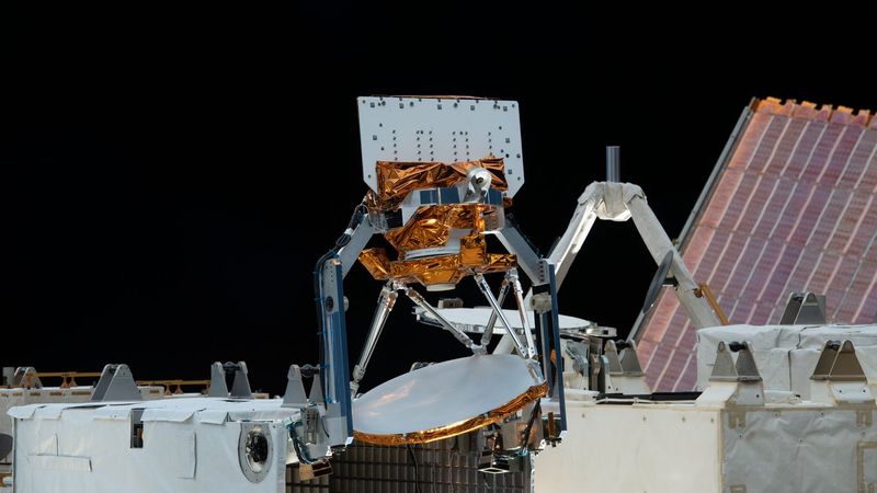
COWVR, at center, and TEMPEST, not shown, were installed aboard the International Space Station in late 2021 and since then have provided valuable weather data to forecasters tracking tropical cyclones. The two instruments are part of the U.S. Space Force STP-H8 demonstration mission. Credit: NASA
In this episode, we talk about a new satellite system from NASA that leverages technologies used in other missions to accomplish the same performance that has been delivered by heritage satellites but smaller and less complex while also being a fraction of the cost.
EPISODE NOTES
(0:55) - Dynamic NASA-Built Weather Sensors Enlisted to Track Tropical Cyclones
What's up everyone? In this episode, The NextByte we're talking about NASA's flying microwave sensors for tropical storm tracking. We also talked about how they cost way less, how they're way more efficient and then use a bunch of corny analogies related to kitchen appliances. I think it's interesting so let's jump right in.
I'm Daniel and I'm Farbod, and this is The NextByte Podcast.
Every week, we explore interesting and impactful Tech and Engineering content from Wevolver.com and deliver it to you in bite sized episodes that are easy to understand regardless of your background.
------
Daniel: What's up everyone? Today we're talking about these awesome NASA weather sensors, the satellites that are going to help us track Tropical Cyclones. I think it's super interesting and I also appreciate how they're taking new technology into account to make it more economical from as pace and size perspective, right? We know that means a lot when you're sending stuff into space, how much it weighs, how large it is. But then also how Its development budget went into it as well.
Daniel: We basically talk about these two new sensor satellites once called COWVR and one calls TEMPEST, and they're replacing, these state-of-the-art satellites that we've been working for the last 15, 20 years. I don't know, anything else to add Farbod before we jump right into it?
Farbod: No, I mean you hit the nail right on the head right context here is pretty easy to get like, you know whether data is important over the continental United States, we can get very accurate data very quickly, when it goes into the waters, like the Pacific Ocean and the Indian Ocean, it's not that easy. We rely on satellites. Having good data about what's going on there gives a better idea what's going on with like tropical storms, cyclones. So, any satellite Tech that can improve on that and make it more efficient is great.
Daniel: And that kind of makes sense, right? We've got a lot of whether specific aircraft really instrumented that fly around over the continents to try and understand what's going on with weather there. We've also got some instruments on our commercial and our passenger aircraft that help fill in the gaps in that data sometimes. But that gives us a really good ground truth of where storms are, how they're going. Basically, when you get to any of the big expanses of ocean, right? So, the Pacific and the Indian Ocean, or the Atlantic Ocean, there's not as many of these and we're relying almost completely on satellites to collect data for weather monitoring, climate change monitoring stuff like that because there aren't all these basically like flying sensors on planes everywhere in the atmosphere telling us what’s going on.
Daniel: As you may or may not know a lot of the largest storms that caused huge devastation to like natural disaster level stuff. All of this, like, it's hard to track because they originated most of them in these large expanses of water where we don't have constant monitoring. So, you know, there isn't a lot of time or a lot of the times, we don't know that its massive storm is coming till it's already formed and then we're like, “oh, crap here's another tropical storm. Let's give it a name. He's going to smash this part of the continent and, you know, cause a natural disaster.”
Daniel: So, I think, and really interesting part of how satellites fill the gap is trying to understand what happens in those gaps, between our other highly more highly instrumented areas. I also think it's interesting that that we are able to use these satellites for long-term weather and climate model predictions. Not just a storm forecast for the next 14 days like what you see, if you flip on your news.
Farbod: Yeah. And it's I guess a layer that goes into the weather prediction is understanding how like micro changes in the environment? Like the ocean surface will have like, cascading effects that lead to specific weather patterns, right? And that'll just like strengthen our fundamentals of understanding how our environment is impacted by all these little changes. So that's like an extra layer added to what we're getting out of these satellites.
Daniel: Yep. I agree. So, let's jump into these two awesome satellites. I love and you're going to keep getting these here, but I love the references this NASA team used to try and contextualize the work that they've done. Basically, everything they do somehow relates back to the kitchen which I think is super cool. So, they've got COWVR, which is the “Compact Ocean Wind Vector Radiometer” that the kitchen analogy they use here is, it's about the size of a mini fridge. And they've also got TEMPEST, which is the “Temporal Experiment for Storms and Tropical Systems”, that's about the size of a cereal box. And what's cool about both of these is they're like flying microwave sensors. So, there's our third kitchen, appliance references, we've got a mini fridge and a cereal box flying around searching for microwaves and this helps them measure not only the speed and direction of winds blowing over the ocean surface, but also precipitation levels, atmospheric moisture, how that moisture is distributed vertically in the atmosphere.
Daniel: So, is it really close to the surface or is it way up in the sky as well as other conditions the ocean surface that interacts with the atmosphere to create new weather pattern. So, between these two COWVR and TEMPEST which again, I would rate these. I think I'd rate these acronyms around like a 6.9-7.1.
Farbod: I also give them a 5.0. I think you're very generous, honestly, TEMPEST is good, COWVR very missing. It sounds like a dairy product if I'm being honest.
Daniel: But you know, you need your caliber to pour over your cereal so yeah, I don't know.
Farbod: It's a mini fridge after all.
Daniel: That's true.
Farbod: It's fitting. Really quick though, before we jump to deep into these, I think it's worth talking about what came before them. Like what these are meant to replace in terms of what they bring to the table. And it's kind of a, I think it's kind of a cool story. So, like there was this project called “The Wind Set Project” and I think it started in the early 2000s where they were like, you know, just like we talked about, we need to have some sort of a satellite system that can give us very accurate weather data when set was funded by the DOD. I think I forgot what the name of the actual satellite was but it was called the Wind Set Project, it starts with a C, I don't know, if it's a Calico, because I know that's not right. But was like something like that. And this thing, it used a radiometer, it was a used, a microwave radiometer, which is just, you're sending out a lot of waves. You're getting the reflection and you're analyzing good to understand, like, what's going down at the ground level at the sea surface level. Now, this thing was like a feat of engineering at the time. I think it launched in 2003, and then it retired in 2020.
Daniel: And that again, think it would last that long, right? I think they originally planned it to last for a decade and ended up back lasting for two which is awesome. We love when Engineers being really proactive to design their systems in away that's a really robust, pays out good for us in the long term where we don't have to end up replacing satellites as soon as we thought. Part of that, because this thing cost, how much like 120 million US dollars for 2003? Which, you know, with inflation might be somewhere like 250 million dollars today. I don't even know.
Farbod: Yeah, and it was huge man. Like it was, they're using metric units here so far imperial unit fans. I'm sorry, but it's 4.7 meters high and that's without the solar sails open and it's about 1.5 meters in diameter. So massive it weighed a 990 pounds it was pretty energy-intensive. So, used 350 watts of power to operate and it did a lot of what the DOD expected out of the system like this, right? Like it did, wind speed and direction, data gatheration, it gathers Sea surface temperature, soaring moisture ice and snow characteristics, water vapor, Cloud water and rain rates. And one of its biggest shortcomings was the fact that it had a lot of moving parts. So, this thing, imagine like a huge dish that's spinning 30 times per minute to gather data, has a bunch of sensors on board. And if I'm not mistaken, stick in some of those had to be like independently actuated as well. So, a lot of moving parts that are going to be operating in space for a very long time. That means you got to do a lot extensive testing, a lot of like redundant system development to make sure it's actually able to operate but again, feat of engineering and it did what it was supposed to do for a very, very long time. But as you said, they didn't think it was going to last this long, so, DOD and like 2012, there were like, alright, we gotta look for a replacement here. It's got to do pretty much the same thing, but once they started doing the analysis of what the system would look like that the cost analysis and the components are like this is pretty complex and if we're going to go through this process, we should make sure that it's as good as it can be. Let's go to NASA! And that's where our story really starts them going to NASA JPL for their expertise.
Daniel: Well and what's awesome about that is the solution that this team from NASA JPL came with, right? This, I would call it a satellite constellation. I'm not sure if only two satellites count as a constellation but you know this this tag-team this dynamic duo of these two satellites. This these two satellites, right? Remember the replacing wind sat which weighed 990 pounds that's 450 kg and use 350 watts of power. They're able to replace this wind sat with COWVR and TEMPEST, right? These two satellites COWVR is only 130 pounds, that 60 kilos. So, a fraction of the weight and size of this huge wind satellite and around one-fifth of the budget. TEMPEST was a flight spare, left over from another mission. They were able to kind of like piggyback on leftover development from the 2018, TEMPEST-D Mission. This one's again about the size of a cereal box it weighs only 8 pounds are 4 kg only uses 6.5 watts of power and had a budget of less than two million dollars. So, they've found a way to collect all the data that wind sat was doing, splitting it up between these two satellites in a way that spent around one-fifth of the budget in a way that's, you know, significantly less mass, significantly less size and it's in a way that we think is going to be more robust because it also uses less energy, uses less moving parts like the things you were talking about. So, they've also got this long looking forecast for this stuff to process like possibly last longer than wind sat ever did. They spent less money to do it as a lot more efficient, I think it's a huge testament to the fact that technology, even though, you know, it may only seem like incremental developments in this space over the last couple of years.
Daniel: It's really developed to a point where we're doing things that are way more efficient, way more significant with way less resources than we were ever able to achieve in 2003. So, I'm excited to see what the TEMPEST and COWVR replacement looks like in 20 years from now because we might have these tiny cubesats that tell us all about the environment, all about our ecosystem, all about our weather, and they may only cost like a couple hundred thousand dollars to get up into space, which would be awesome.
Farbod: Yeah, and like, one of the most interesting things about this article, you touched on it again, is TEMPEST and actually COWVR they are both leftovers or inspirations from like other projects. So, TEMPEST you said it was from the TEMPEST-D project, 2018. COWVR actually comes from the JASON-3 mission that was like a US and EU collaboration to measure the height of the ocean surface and so like when the DOD went to NASA JPL, this lead engineer Shannon Brown was like, “Hey, we've actually like been doing a lot of work for microwave radiometers on this project, we can pretty much take over most of the hardware and most of the design and make it adjusted to do what you guys want to do. And, you know, it has a couple of cool things that came from it, it weighs 130 pounds, like you said, use this 47 Watts cost 24 million dollars, like that's about one-fifth of what the original estimate was for the wind sat project and it completed on budget and on time in 27 months and I'm thinking that's likely due to the fact that this was already done before for different project.
Daniel: And it's a huge testament to their being like a lot of Firepower and a really strong team behind this because, you know, you and I both have been a part of a lot of engineering projects with a lot of smart engineers and a lot of people working as hard as they can. I can't think of many that end up on time and under budget, and I'm a program manager that's literally my job.
Farbod: If anyone knows it's you, right, like that, you got that Insight.
Daniel: So, it's the fact that, that's the case here is, you know, it seems like something we could glaze over, but anyone who's Engineered a project with a strict time and a strict budget, will know how hard that is to do usually have to compromise on one or both to deliver the solution you want. The fact that this team did it and made a solution that works really well, let's talk about in a second how its deployed in space and then some of the ways that they've tested it. But again, a lot of kudos to this team at NASA JPL and then this engineer Shannon Brown, who recognized this microwave radiometer they used for Jason-3. And also, the leftover engineering they had from Tempest-D, was able to be repurposed again for this new mission to replace Wind Sat.
Farbod: And I want to quickly know that one of the big reasons that they were able to have so many savings in terms of cost weight and power consumption is because like then, again you mentioned it, we've made so much progress in the past two decades that we can do things completely differently now that we probably couldn't have imagined doing in the 2000s. For example, they were talking about how a lot of these sensors and instruments that were on board on the Wind Sat Project to like make sense of the data that's coming in. They actually we don't really need to be here anymore because a lot of that has just been rendered useless by algorithms that Shannon's team has developed. So now we have like code doing some of the heavy lifting that we would have hardware to do and that hardware would need like specific sub systems to support it. And then, you know, it adds on and on and on and for whatever that they need to be moving, they've, they're not independently power you anymore. They have this one turntable that handles every instrument that's onboard.
Farbod: So, they made alike, a lot of novel engineering tweaks here and there, and also leverage the power of the resources that we have now. So, you know, in 20 years we're I feel like we're just in the beginning of AI, imagine it taking off exponentially in 20 years this going to look way, way different.
Daniel: Yeah. I mean it's was that Mark in the Senate that software is eating the world around us. This is a very key example that we had problems that were solved with electrical and mechanical hardware and the algorithm and this team at the JPL have been working on, have literally been able to replace all that infrastructure, all that mechanical and electrical infrastructure with a few lines of code and simplified the remaining hardware into something that's a lot more robust requires a lot less energy and is a lot less likely to fail. And I mean I'm not a software engineer but this makes me wish I was because of the magic that goes into this and you know, they're able to significantly move the needle on projects like this, just by simplifying stuff using software.
Farbod: I feel like we're seeing the epitome of the perfect harmony between software and hardware resources, coming together to make a very well optimized piece of product?
Daniel: Yeah, yeah. No, it's awesome.
Daniel: So, let's talk about how these two, this COWVR instrument and this TEMPEST instrument are deployed, right? So, we talked, I think it was in early, twenty-one or late 2020, I think it's early 2021. It was set up on a SpaceX mission to the International Space Station and that's interesting because Tempest-D was originally a flight spare for its own cubesat demonstration, right? So, it was going to be its own standalone satellite floating in space in the orbit. But the reason that they attach these to the International Space Station is really, really interesting because the unique orbit of the International Space Station compared to other satellites, actually has them passing over the tropical bands of the world more frequently than other satellites do. I think it passes over tropical areas of the world? Like maybe I think it's 10 or 15 times a day. And it's also a sun-synchronous orbit, which means, checks in on the same spots at the same time every day, so you can take almost a time-lapse image if you will, of these spots 10 to 15 times a day with exact same environmental conditions from the Sun so you can compare, how things are changing over time.
Daniel: I think that's really interesting because since it's on the International Space Station, right? It feels like this, just one satellite, one orbit path, right? But what's interesting is that, these systems were designed such that they could also be their own Standalone satellite like wind sat was. And we'll talk about that being a feature development in the future. But at least, now for the proof-of-concept, how they're testing these, it being attached to the International Space Station is pretty cool and I didn't know all this stuff about the unique orbit pattern of a ISS. I don't know if you did man?
Farbod: I didn't need it. This is the first time that I was learning about it but it makes so much sense, right? Like by the way, I don't think we said it earlier, the reason that there's two satellites now working in unison, instead of the one is because COWVR like we're saying we came from a different mission, sort of TEMPEST. They both cover like let's say 50% of the functionality. So, COWVR focus is like pretty much completely on the wave, the ocean wave speed and direction. TEMPEST is more focused on the atmospheric moisture and it's like vertical density. So, like you know, from like 0 m, like ocean surface all the way to the mountains, like how dense is the amount of moisture at each elevation? So together they're able to provide the model and the data that we were getting from the separate, the wind sat project.
Farbod: But you layer it on to the sun-synchronous orbit of the ISS and it makes so much sense because like you're saying what we can end up getting is an entire time lapse of like during different seasons during different like times of day looking at the same spot. What does it look like? And that again feeds into our fundamental understanding of how these like small changes in the oceanic waves will lead to like different environmental catastrophes that we see and how do we like prevent against it predicted earlier etcetera. etc. etc. Super cool.
Daniel: Yeah, I think, I think it's awesome and really cool demonstration of that. Actually, just came in December 2020. So late last year COWVR and TEMPEST images were the key sources used by forecaster, a typhoon center in Pearl Harbor Hawaii to pin down the location of a tropical Cyclone, I think tropical Cyclone Mandous, which then later came through the Bay of Bengal and Southern India and later December 2022. So, these images from COWVR and TEMPEST, remember the goal here is to be able to identify storm patterns, tropical storm patterns in these wide-open areas in the ocean where we don't usually have the ability to forecast well and advance what's going on. These two instruments once were meant to replace this huge honkin, really expensive Wind Sat Project, the images from COWVR and TEMPEST were like the key sources that this forecaster used to be able to predict where a cyclone was and to identify it well, before it ever hit the Bay of Bengal and India, which gives people warning, gives weather forecasters time to focus on this area and to tell everyone what's going on. I mean, it's like I can't, I don't think you can ask for a better proof of concept of what this thing supposed to do, then doing exactly what it's designed to do and giving people enough, warning ahead of time to understand what's going on before a tropical Cyclone hit Southern India.
Farbod: Absolutely. Absolutely. And I think it's also worth noting that this is like relatively new technology so people might be like, well, like how does it compare to them much more complex one that we had in the past with the more sensors and more moving parts? Well, this data looks like the NRL has been the one that's holding onto the data but they've been distributing it to different sensors, I mean, different sectors. So, like you said the joint typhoon warning centers using it, and so is the natural Hurricane Center and it looks like that the data that we've been getting from both of these satellites meets the quality of what we were seeing from Heritage satellites. So, it is very detailed and as good as we want it to be, to be able to make those predictions. And that just like, is a testament to the engineering feat that now is a successor to what was already a pretty like significant engineering feat.
Daniel: And one thing I really liked about this is obviously, right? It's an awesome win all on its own that using something with a smaller footprint, that's more robust that costs way less, that weighs way less, that's way smaller that it performs just as well as the more expensive operational sensors. That's awesome. That's a win on its own. But what's even cooler is that they've been able to collect more data than the previous operational sensor. So, they're trying to take a closer look at these surface wind speed and direction data, not just the imagery that other operational sensors collect to see if they can do something to reinforce and to improve their machine learning models and their other forecasts for tropical Cyclones and predictions. And they're using this as like, an additional data source to help ground a lot of other forecasting models, which I think is pretty interesting because, you know, even though it's directly intended to track tropical Cyclones, they're able to use this to improve long-term predictions on climate models on weather and even trying to like peer into the mystery that is how air and sea interactions affect all this. I think the fact that they were been able to collect more data on this, means that weather forecasting will continue to improve over time. It's not just a one-time benefit that you get, where, you know. Now we've got this capability to detect tropical Cyclones. We're also going to be improving our ability to predict them and how they operate, and what causes them and how that may impact our ecosystem in the long term.
Farbod: Absolutely. and I think, one thing that's kind of worth noting. I'm not, you know, great when it comes to satellite technology. I'm definitely a novice. But they were talking about how that technology that were using for the radiometer on the Wind Sat Project was called the scatterometer. So, it's like microwaves being sent out like an ultrasonic sensor, you send out a bunch, you get a bunch of back and then you're analyzing it. But I think the frequency that they were originally operating at made it acceptable so that if there's a lot of clouds in the way, it could get distorted and you couldn't completely seem to the eye of the storm. And if I'm not mistaken COWVR actually overcomes that limitation, so that you can get much accurate data even in the most distractive scenario that you could think of. So, wins all around.
Daniel: I think that's sweet. And another part I just want to mention quickly. They mentioned that this is just the start, right? This is a proof of concept for them, that will with the success that they've seen this reinforces, the idea that they could continue to develop tiny satellites like this that have these, you know, smaller more lightweight, more efficient versions of these really expensive operational sensors that we've got deployed right now and they're saying that in the future, we can have whole constellations of these things in the sky that help us to very well understand what's going on in the Earth's atmosphere, which I don't know if you're like me. I've got a huge pet peeve for the fact that I like weather forecasters, I have no idea how we don't have the technology to be more accurate. So, something like this, you know, touches that pain point for me and might help address at some point in the future when we've got a bunch of these satellites in the sky and they're actually really economical and they do a great job at helping improve our understanding of what's going on in the atmosphere and that will reinforce our ability to improve storm forecast and stuff like that.
Farbod: Well, I think even like in the article, the principal for the project was like look what it used to cost for us to make one satellite like this. Now we can use to make 4-5 and just imagine what that's going to mean for like our weather forecast, right? So, you're absolutely right. Maybe that weather app is finally going to become useful knows.
Daniel: I hope so. Before we wrap up here, I want to do a quick rundown of what this technology is and then a few key takeaways, I'm borrowing a lot of these actually from an awesome article on the NASA website, that explains this, so I'll run through kind of the technology they did and then five key takeaways from it.
Daniel: So, we've got in the past we've had these huge flying really expensive satellites in the sky trying to collect a lot of data, one of those was called Wind Sat that was recently retired. This team from NASA is going to replace that with two smaller satellites once called COWVR and once called TEMPEST, they're able to do this with a fifth of the budget. Do it a lot smaller, do it a lot more efficiently. And because of this, these developments that they've had, they've been able to collect the same high quality data as their larger predecessors, that It's takeaway number one. Number two, they all have the potential to improve storm forecast, moving forward, that's something that I'm really excited about. Number three, they have comprehensive data that they can help to improve climate and weather model predictions moving forward, which will further reinforce our ability to predict storms and forecast. Takeaway number four, they'll be able to shed light on how air and sea interactions affect our weather and climate and that's something that is not well understood right now. And number five, finally, they will pave the way for a future constellation of these satellites in the sky that help improve articulate as one through form and, you know, bring this all to life,
Farbod: That's money. That is the perfect recap, my friend.
Daniel: Well, I can't take credit for it but I'm glad I delivered it.
Farbod: All right, everyone before we do the final wrap up quickly, I want to thank you guys specifically our friends in the UAE and if I'm not mistaken Canada. You guys made us trend over the past week. So, thank you so much for your support. We've been borrowing this phrase from another podcast that we like, but if you don't know, this podcast is not free. Actually, there's a “unspoken agreement” that we're going to have with our listeners, which means we asked you guys to go on your Spotify app or whatever podcast app you’re using; follow, subscribe, rate. And that is how you pay for the “beauty” is a strong word but you know, the amazingness of this podcast also a strong word, but I will leave you on that note and thank you so much for listening. As always, we'll catch you in the next one.
Daniel: Peace.
------
That's all for today The NextByte Podcast is produced by Wevolver, and to learn more about the topics with discussed today visit Wevolver.com.
If you enjoyed this episode, please review and subscribe, via Apple podcasts Spotify or one of your favorite platforms. I'm Farbod and I'm Daniel. Thank you for listening and we'll see you in the next episode.