MEMS vs FOG IMUs: Exploring Underwater Navigation Technology
Explore advanced underwater navigation tech with Deep Trekker ROVs. Learn about MEMS and FOG IMU, Dead Reckoning, and USBL integration for precise positioning.
17 Jul, 2024. 7 min read

This article was first published on
www.deeptrekker.comUnderstanding Underwater Navigation
In the navigation of underwater environments, knowing your position is critical, yet traditional Global Positioning System (GPS) solutions are rendered ineffective due to the limitations of underwater signal propagation.
In such challenging conditions, Deep Trekker’s Remotely Operated Vehicles (ROVs), equipped with a suite of advanced sensors and navigation methods, offer a sophisticated alternative.
Underwater navigation presents unique challenges owing to the attenuation and distortion of signals underwater, necessitating the development of specialized techniques. Deep Trekker ROVs leverage a diverse & robust sensor suite as well as sensor fusion algorithms to navigate in these complex environments. This article examines the complexities of underwater navigation, demonstrating the role of Inertial Measurement Units (IMU), Ultra-Short Baseline (USBL), Doppler Velocity Log (DVL), Dead Reckoning, and other cutting-edge technologies employed by Deep Trekker ROVs.
Key Underwater Navigation Sensors
ROVs integrate a comprehensive suite of advanced sensors and methodologies, each playing a crucial role in ensuring reliable underwater navigation. Below is an overview of key sensors
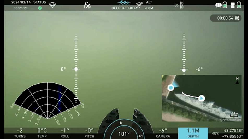
Camera: Serving as the primary source of situational awareness, high-definition cameras provide operators with real-time video feeds. They facilitate easy maneuverability during inspections of underwater assets and structures, offering vital visual cues essential for navigation.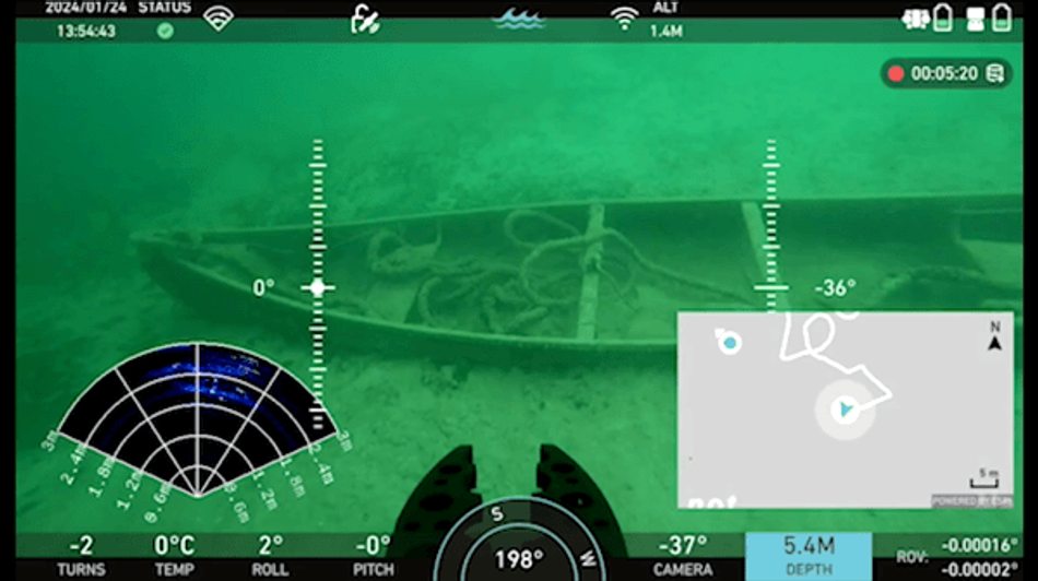
Pressure Sensor: Accurate depth measurement capabilities enable ROVs to maintain consistent altitude above the seabed, ensuring safe navigation and inspection operations. The depth / pressure is used to maintain a precise depth below the surface of the water column. The DVL also measures the altitude (vertical distance from the seabed).
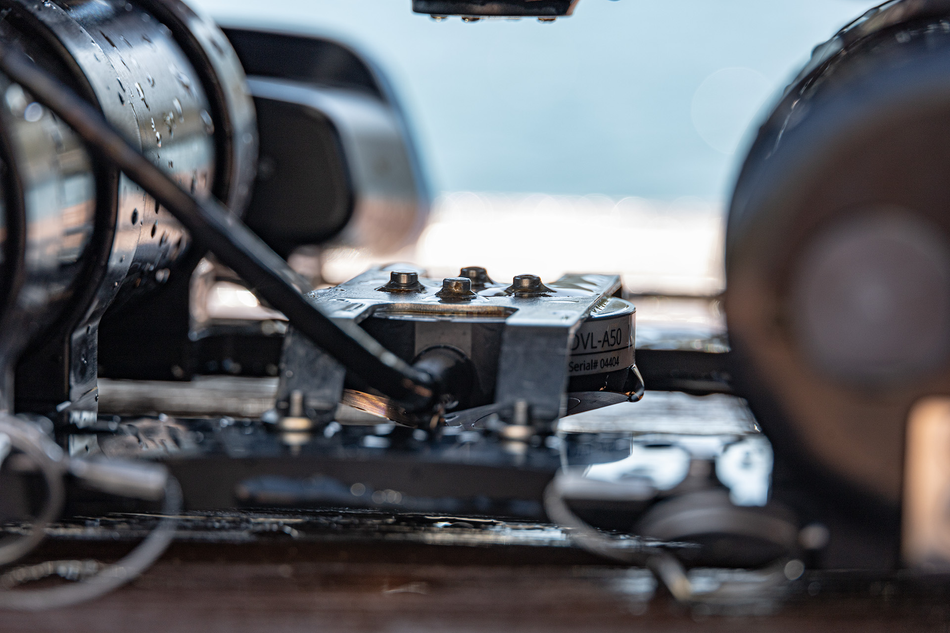
Doppler Velocity Log (DVL): By measuring changes in sound wave frequencies, DVL systems determine the ROV's speed, direction, and altitude relative to the seabed. This information is vital for maintaining course accuracy and executing dynamic maneuvers.
Multibeam Imaging Sonar: Utilizing sound waves for real-time imaging, multibeam sonars offer detailed underwater visibility even in low or zero-visibility environments. They play a crucial role in navigation, object detection, and seabed mapping with exceptional resolution, serving as the primary visual aid when water clarity is compromised.
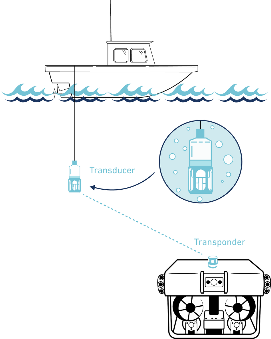
Ultra-Short Baseline (USBL): Integration with USBL enhances navigation accuracy and enables autonomous navigation and position holding in challenging underwater conditions.
Dead Reckoning: Dead Reckoning is a fundamental navigation method to estimate position based on previously known position, velocity, and heading information. By continuously integrating sensor data and accounting for external factors such as current drift, Dead Reckoning algorithms enable ROVs to maintain correct position estimates over extended mission durations.
USBL Integration: Achieving Underwater Navigation Precision
The integration of USBL systems transforms underwater navigation, offering exceptional accuracy and reliability. By triangulating the ROV's position relative to surface transducers, USBL technology enables real-time mapping and localization underwater.
The seamless integration of USBL positioning enhances the capabilities of underwater ROVs, providing users with comprehensive navigation and mapping solutions tailored to diverse underwater applications.
USBL triangulation quality is not as accurate compared to GPS triangulation quality; however, the overall quality of USBL is improved through sensor fusion.
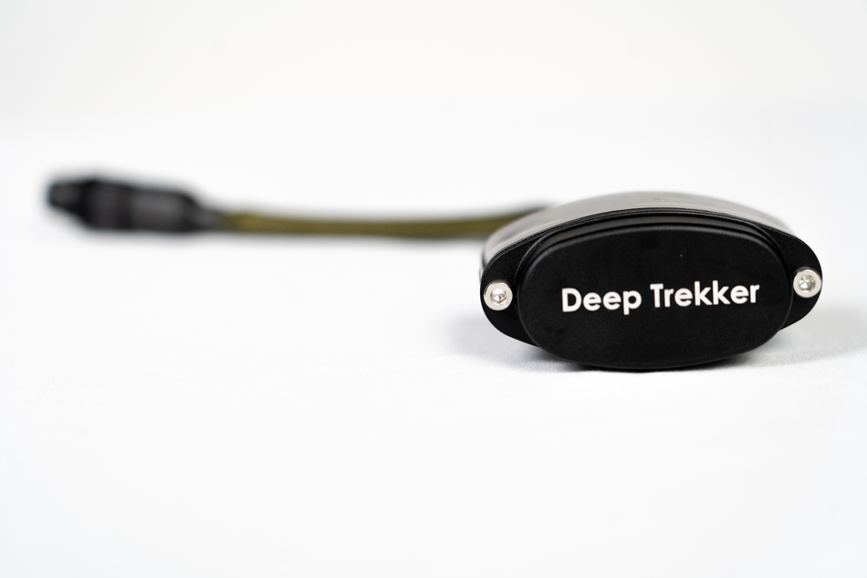
Exploring IMU Technology
IMUs are integral components of underwater navigation systems, providing crucial data on an ROV's orientation and motion.
Let’s take a look at both FOG and MEMS based IMU systems.
MEMS vs. FOG IMU: Choosing the Right Technology for Underwater Navigation
In the world of underwater navigation, the selection of the appropriate IMU technology plays a crucial role in ensuring accurate positioning and stable control of ROVs. Two prevalent IMU technologies, Microelectromechanical Systems (MEMS) and Fiber Optic Gyroscope (FOG), offer distinct advantages and trade-offs, each suited to specific applications and operational requirements.
MEMS IMU: Miniaturization and Cost-Efficiency
MEMS IMUs are characterized by their compact size, low power consumption, and cost-effectiveness.
Leveraging microfabrication techniques, MEMS IMUs integrate miniature sensors, including accelerometers and gyroscopes, onto a single silicon chip. This miniaturization enables MEMS IMUs to be seamlessly integrated into compact ROV designs, offering enhanced maneuverability and operational flexibility.
Furthermore, MEMS IMUs boast relatively lower production costs compared to their FOG counterparts, making them an attractive choice for budget-conscious projects and applications requiring mass deployment of underwater vehicles.
Despite their compact size and cost-effectiveness, MEMS IMUs deliver respectable performance in terms of accuracy and reliability, meeting the demands of many underwater navigation tasks.
One of the main drawbacks of MEMS is that they are less stable compared to FOG systems. MEMS systems usually rely on a compass to ensure heading stability. This fixes the heading stability issue while maintaining cost-effectiveness, however, this also means that MEMS systems tend to be susceptible to local magnetic distortions.
FOG IMU: Precision and Stability at a Higher Cost
In contrast, FOG IMUs offer exceptional precision and stability, making them well-suited for demanding underwater navigation applications that require more finite accuracy and long-term reliability. FOG IMUs utilize the principles of interferometry, where light waves traveling through a coiled fiber optic loop experience changes in phase due to rotation, allowing for accurate measurement of angular velocity.
The inherent stability and accuracy of FOG IMUs make them ideal for tasks such as underwater mapping, seabed surveying, and pipeline inspection, where positioning and motion tracking are critical. However, FOG IMUs typically command higher production costs and exhibit larger physical footprints compared to MEMS counterparts.
In addition to their cost, it’s important to note that FOG IMUs also require a significant amount of time to boot up and calibrate (approximately 15 minutes). During this time, the vehicle must be completely flat and stationary on solid ground, which makes deployment off of a boat problematic.
Choosing the Right IMU for Your Application
When selecting between MEMS and FOG IMUs for underwater navigation, it is necessary to consider the specific requirements of the intended application, including accuracy, cost constraints, operational conditions, and deployment scale. For projects prioritizing compactness, cost-efficiency, and versatility, MEMS IMUs offer an attractive solution, providing great performance for a wide range of underwater tasks.
On the other hand, applications demanding uncompromising precision and long-term stability may favor the superior performance offered by FOG IMUs, despite their higher cost and larger form factor.
By carefully evaluating the trade-offs between performance, cost, and operational requirements, teams can make informed decisions when selecting the most suitable IMU technology for their underwater navigation needs.
While MEMS IMUs excel in compactness and cost-efficiency, FOG IMUs offer unmatched precision and stability, catering to the diverse needs of underwater inspections, research, and industrial applications.
By understanding the strengths and limitations of each IMU technology, stakeholders can make informed decisions to optimize the performance and efficiency of their underwater navigation solutions.
Dead Reckoning Techniques
Dead Reckoning serves as a complementary method for underwater navigation, particularly in scenarios where external positioning systems may be unavailable or unreliable.
By continuously integrating IMU data with velocity and heading information, dead reckoning algorithms estimate the ROV's position based on its previous known location. Deep Trekker ROVs utilize Dead Reckoning techniques to maintain navigation accuracy in sub-sea GPS-denied environments.
ROV Navigation With Sonar
With the unique profile of acoustic interpretation, sonar systems can be very valuable when mounted with an ROV. Without sonar, the pilot of the ROV will have to rely on the visual relay of the objects and features through a camera. In low visibility environments, it might be hard to see with the range often being under a meter.
Sonar systems will drastically increase this range, allowing the pilot to detect objects from much further away. Instead of going over the seabed to find objects, the ROV can remain stationary and scan the entire environment. The pilot can then get an understanding of the area with the man-made objects, natural surfaces, and areas to ignore.
Sensor Fusion: Enhancing Navigation Precision
 The synergy of IMU, DVL, and other sensors through sensor fusion techniques enhances the accuracy and reliability of underwater navigation. By intelligently integrating data streams and compensating for sensor inaccuracies, ROVs achieve navigational precision and stability.
Sensor fusion algorithms optimize control responses, mitigate environmental disturbances, and enable autonomous operation, thereby streamlining underwater operations and inspection tasks.
Through continuous refinement and calibration, sensor fusion elevates the capabilities of Deep Trekker ROVs, ensuring seamless navigation even in dynamic underwater environments.
Advanced Underwater Positioning Systems: A Comparative Analysis
The classifications of positioning systems can be divided into three overarching tiers, each catering to specific requirements and budgets.
High-End Military Grade Solutions: "The high-end, military-grade solutions are typically FOG IMU-based, without the need for DVL integration, employing accelerometers and gyroscopes, albeit at a prohibitive cost," explains Nemanja Kliska, Deep Trekker Team Lead and Autonomy Systems Engineer.
These top-tier systems, typically priced between half a million to several million dollars, prioritize uncompromising accuracy and reliability. Utilizing FOG IMU-based technology, these systems, commonly found on military vessels and submarines, employ gyroscopes and accelerometers to achieve precise navigation without reliance on external sensors like DVL.
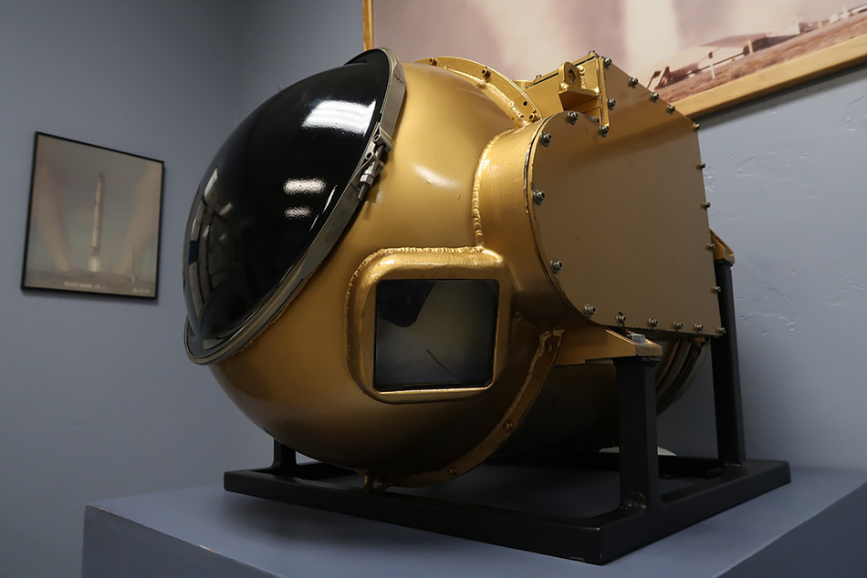
AC Spark Plug Titan Inertial Measurement Unit
High-End Civilian Systems: Positioned below military-grade solutions, high-end civilian systems offer advanced navigation capabilities at a relatively lower cost. Incorporating IMU or AHRS technology - comprising accelerometers, gyroscopes, and magnetometers - these systems ensure robust performance in various underwater environments. Moreover, some variants employ FOG systems to mitigate heading drift, enhancing positional accuracy.
MEMS-based Systems: Representing the next tier, MEMS-based systems provide a cost-effective alternative with acceptable performance metrics. Integrating MEMS gyroscopes and accelerometers, these systems offer satisfactory accuracy under optimal conditions. However, they rely heavily on compass or magnetometer data and require continuous calibration to mitigate errors and environmental interference, and require the incorporation of DVL systems.
Advancing Underwater Navigation with Deep Trekker ROVs
In conclusion, the utilization of advanced sensors and positioning methods transforms underwater navigation with Deep Trekker ROVs. Through the integration of IMU, DVL, USBL, and other cutting-edge technologies such as Dead Reckoning, Deep Trekker ROVs offer groundbreaking precision and reliability in navigating challenging underwater environments.
With our commitment to advancing underwater technology, Deep Trekker remains at the forefront, providing innovative solutions for underwater inspections and research, continuing to redefine the possibilities of underwater navigation, and paving the way for future discoveries and advancements in marine industries.
Our experienced team is at your service to offer expert guidance for a wide spectrum of applications, ranging from inspecting hull vessels to water tanks to conducting underwater assessments across various industries. We ensure tailor-made solutions that precisely match your specific requirements. When you're prepared to acquire your Deep Trekker ROV, don't hesitate to get in touch with us for a personalized quote.